Winter hiking
• Altopiano di Pine' and Valle di Cembra
Walk from Lisignago to the S. Leonardo church
Short walk through the vineyards of the Cembra Valley on secondary asphalted roads; interesting itinerary in terms of landscape and culture
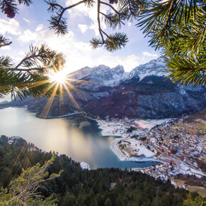
The itinerary allows you to enjoy a wonderful view from the panoramic hill just below the town of Lisignago, where the small church of San Leonardo stands, with its valuable fifteenth-century frescoes inside. The antiquity of the church, the vineyards and the Avisio river offer a magical atmosphere of silence and sacredness.
Responsible for this content Azienda per il Turismo Altopiano di Piné e Valle di Cembra
Verified partner
Explorers Choice
Photo: Fotoamatori di Segonzano, Azienda per il Turismo Altopiano di Piné e Valle di Cembra
Photo: Rossi Bruno, Azienda per il Turismo Altopiano di Piné e Valle di Cembra
Short walk through the vineyards of the Cembra Valley on secondary asphalted roads; interesting itinerary in terms of landscape and culture
easy
Distance 1.1 km
Duration0:30 h
Ascent128 m
Descent130 m
Highest point585 m
Lowest point455 m
The itinerary allows you to enjoy a wonderful view from the panoramic hill just below the town of Lisignago, where the small church of San Leonardo stands, with its valuable fifteenth-century frescoes inside. The antiquity of the church, the vineyards and the Avisio river offer a magical atmosphere of silence and sacredness.
Author’s recommendation
Among the points of interest along the route we point out the church of San Leonardo.
N.B .: the church of San Leonardo is usually closed and is open only upon prior request to the Cembra information office.
For a gastronomic break we suggest the "Lisgnàc" restaurant bar in the town center.
ATTENTION: Before starting the route, check the snow conditions with our offices. Tel. +39 0461 557028 / info@visitpinecembra.it
Author
Responsabile A.p.T Piné Cembra SS
Update: March 21, 2022
Difficulty
easy
Technique
Stamina
Experience
Landscape
Highest point
585 m
Lowest point
455 m
Best time of year
Jan
Feb
Mar
Apr
May
Jun
Jul
Aug
Sep
Oct
Nov
Dec
Safety information
Experience walking along irregular mountain trails is recommended. It may happen that the path is not clear form snow. In the event of fresh snow, microspikes are recommended. Be careful of ice when temperatures are particularly low.
Please note that the practicability of the itineraries in a mountain environment is strictly linked to the contingent conditions and is therefore influenced by natural phenomena, environmental changes and weather conditions. For this reason, the information contained in this page may have changed. Before leaving for a tour, make sure the path you will approach is still accessible by contacting the owner of the mountain hut, the alpine guides or the visitor centres of the nature parks, the info offices of the local tourist board.
From the starting point (parking lot under the Parish Church of Lisignago), descend on the paved road to the ancient church of San Leonardo, located on a hill overlooking the Avisio river. Once you reach the church, you can admire the nineteenth-century portico, the bell tower and the bell from 2002, with a decoration designed by the artist Marco Arman. The interior is decorated with a valuable pictorial cycle dating back to the second half of the fifteenth century, made by a traveling painter from Fiemme.
Note
all notes on protected areas
Public transport
From the Trento bus station, take line B102 towards Cavalese (Trento - Cembra - Capriana - Cavalese) and get off at Lisignago.
Getting there
Coming from the A22 Brenner motorway, both from the south and from the north, take the Trento Nord exit, drive along the S.S. 12 of Brennero northward untill the junction with Lavis, to then pass on the S.S. 612 Lavis - Castello di Fiemme which leads to the Cembra Valley and to the town of Lisignago.
Parking
Car park nearby the parish chruch of Lisignago (marked with"P" sign).
Coordinates
DD
46.160698, 11.186614
DMS
46°09'38.5"N 11°11'11.8"E
UTM
32T 668822 5114226
w3w
///catchers.underfed.tagging
Arrival by train, car, foot or bike
Equipment
See the list below.
Similar routes nearby
From Cembra to Santo Lake in winter
From Lago Santo to Roccolo del Sauch
Ring route within the Laghestel Nature Reserve in winter
Tour of the the Piné Plateau lakes in winter
Up to the peak of Dosso di Costalta in winter
Fai della Paganella - Water & beech trees tour
Fai della Paganella - Percorso dell’otto
These suggestions were created automatically.
Difficulty
easy
Distance
1.1 km
Duration
0:30 h
Ascent
128 m
Descent
130 m
Highest point
585 m
Lowest point
455 m
Out and backScenicFamily-friendlyCultural/historical interestInsider tip